
Researchers discovered that an anomalous signal emerged across the boundary between the Atlantic Ocean and the African continent, in an old survey.
by Blue Africa News
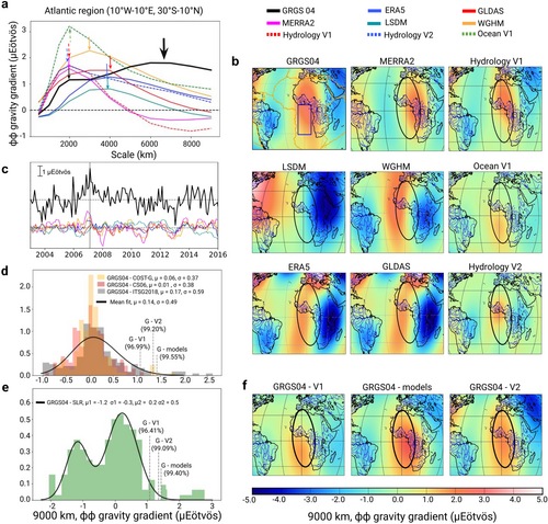
A team of researchers identified a large-scale gravitational anomaly over the eastern Atlantic Ocean that occurred between 17 and 19 years ago, peaking in early 2007.
The anomaly, detected through data from the Gravity Recovery and Climate Experiment (GRACE) satellites covering the period 2003–2015, could not be fully explained by surface water changes or movements within the Earth’s core. The anomoly only recently came to light, thanks to research going back through old data.
The findings, published in August in the Geophysical Research Letters journal, indicate that the anomaly may have occurred for two years, from 2006 -2008, causing a rapid redistribution of mass in the deep mantle, in the process altering the earth’s magnetic field.
“While the result and its publication were certainly a source of satisfaction, the dominant thought was to consider the next steps and possible implications,” said Mioara Mandea, co-author of the study.
Mandea doubles up as a geophysicist at the National Centre for Space Studies (CNES) in France, and a principal investigator for the European Research Council’s Gravimetry, Magnetism, Rotation and Core Flow project.
“As is often the case in scientific research, my initial response was one of questioning: is the signal genuine, how can it be validated, and how should it be interpreted?” she noted.
The researchers discovered that an anomalous signal emerged across the boundary between the Atlantic Ocean and the African continent, with a high intensity in January 2007 at the largest 9,000 km spatial scale of the analysis.
The anomaly, they determined, followed a North-South alignment with a scale of 7,000 km, making it unique from other gravity gradient signals detected in the region between 2003 and 2016.
In verifying the findings, the team analyzed four sets of GRACE monthly geoid models, confirming that the signal remained consistent even when changing reference periods. Additionally, they applied a one-year moving average to minimize seasonal variations in the spatial gravity maps.
Oliver Ochieng, Blue Africa News